Lake Wanaka - photos
 |  |  |  |
 |  |  |  |
 |  |
About Lake Wanaka
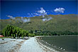
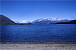
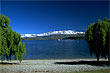
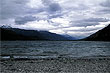
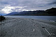
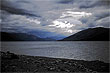
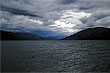
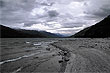
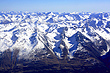
 Lake Wanaka in the Otago region is the fourth largest lake in the country and estimated at over 300 m (980 ft) deep. It sits at an altitude of 300 metres above sea level and 192 km² (74 sq mi) in area. Surrounded by mountains and hills, some peaks rise 1700 metres above the lake. There are a number of small islands in the lake that serve as ecological sanctuaries.
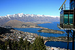
A town that shares the name 'Wanaka', resides on the southern shoreline of the lake and has great views of the lake and surrounding mountains. Wanaka is a popular tourist destination and often compared with Queenstown to the south.
Author & photographer: David Johnson (Virtual New Zealand). Providing a credit or link is appreciated.
Our content: logos, site names, text, photos, and website design are protected by international copyright law.
Original versions of our photos can be purchased / licensed & web versions can be shared subject to conditions.