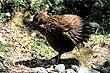
Fiordland National Park - photos
 |  |  |  |
 |  |  |  |
 |  |  |  |
 |  |  |  |
Related Photo Galleries | |||
 |  |  |  |
About Fiordland National Park
 Fiordland occupies much of the south-west coast of the South Island and penetrates a good distance inland. It lies within a protected wilderness called 'Fiordland National Park'. It is the largest
national park in the country and one of the largest in the world.
The name 'Fiordland' is derived from the word 'fiord' which in turn originates from the Norwegian
word 'fjord'.
Fiordland occupies much of the south-west coast of the South Island and penetrates a good distance inland. It lies within a protected wilderness called 'Fiordland National Park'. It is the largest
national park in the country and one of the largest in the world.
The name 'Fiordland' is derived from the word 'fiord' which in turn originates from the Norwegian
word 'fjord'.
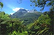
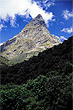
Fiordland contains some of the most dramatic landscape on the planet. Douglas Adams, the author of Hitchhiker’s Guide to the Galaxy, summed up Fiordland best in his book 'Last Chance to See' where he wrote:
Fjordland, a vast tract of mountainous terrain that occupies the south-west corner of South Island New Zealand, is one of the most astounding pieces of land anywhere on God's earth, and one's first impulse, standing on a cliff top surveying it all, is simply to burst into spontaneous applause. It is magnificent.
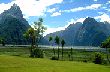
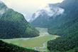
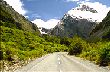
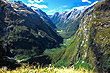
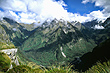
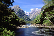
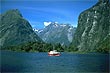
Fiordland has 14 fiords, of which Milford Sound is the one that most visitors visit. Part of the reason for this is accessibility as there is a well serviced road here. Doubtful Sound, the next most accessible, is more difficult to reach as it requires a booked tour which traverses a road, a lake, followed by another road and then you have to return. However, the trip is highly recommended as the scenery is absolutely stunning. Doubtful has 365 islands and many more branches and arms than Milford. It is around ten times larger than Milford, but the jury is out as to whether it is more scenic. Suffice to say that Doubtful is much bigger, but Milford has steeper mountains and cliffs. Both rank as the most desirable destinations in New Zealand. There are many other fiords in the park, but they can only be accessed by boat or viewed by plane and helicopter.
Milford Sound has the most tours to choose from including a boat tour that poke their boat bows into some of the waterfalls allowing visitors to collect and drink what is reputed to be the freshest water in the world.
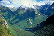
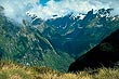
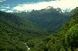
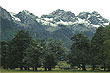
Besides Fiordland's spectacular fiords and steep coastal mountains, the park is also clothed in lush ancient forests, which are dissected by swift rivers. These rivers are the result of snow melt and excessive rainfall. Waterfalls are also common. Many of these waterfalls thunder into fiords such as Browne Falls, while others like Sutherland Falls plunge from lakes above into the valley floor below. Both these waterfalls rank among the world's tallest.
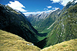
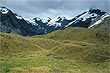
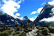
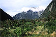
The park is also famous for its walks as these offer the best vantage points to the most pristine areas of the park. The most well known walk is the 'Milford' which was dubbed 'the finest walk in the world' by the London Spectator back in 1908. The title stuck and this is the phrase you see on tourist brochures today. However this is not the only great walk here. Other walks in Fiordland include the Kepler, Hollyford, Caples, and Greenstone rival the Milford and thejury is out as to which is the best walk. The track many say rivals the Milford for scenery is the Routeburn and it is truly magnificent. This track cuts through both Fiordland and neighbouring Mt Aspiring National Park, so there is a lot of variety in the landscapes onroute. It differs to the Milford Track in that it is more of an alpine walk, while the Milford primarily passes through valleys and in the lowland forests with one major ascent. This alpine ascent of Milford known as the Mackinnon Pass, offers two great views, i.e., Clinton Valley and Arthur Valley. The Milford Walk also has the advantage of ending in Milford Sound another huge attraction.
In summer, average fitness is all that is required to do most of these walks even though they range from 3 to 5 days. More experience is needed in other seasons. Guided walks are available for many of these tracks. Not only is the accommodation better, you get meals too and what better way to celebrate the end of each day with a fine meal and wine. Additionally, your pack is carried for on organised treks giving you the freedom to concentrate on the scenery and take photos.
Most of the tracks in Fiordland have excellent infrastructure. i.e., good bridges, walking platforms, stairs, and gravel paths where necessary. There are also a number of official short walks in the park including the beginning or end of some of the more extensive tracks including the end of the Routeburn or the Manapouri end of the Kepler.
Author & photographer: David Johnson (Virtual New Zealand). Providing a credit or link is appreciated.
Our content: logos, site names, text, photos, and website design are protected by international copyright law.
Original versions of our photos can be purchased / licensed & web versions can be shared subject to conditions.