Google Maps of New Zealand with Search
The map below displays the country of New Zealand. To see contours and mountainous terrain, coastline, cities, towns, and even buildings, switch to satellite mode. You can zoom in to street level for greater detail. To view the map in fullscreen, click on the icon located at the top-right corner of the map. Additionally, right-click on the map to view the latitude and longitude coordinates of any given point.
TIP: Go fullscreen by clicking the icon at the top-right of the map. Then drag the person icon located at the bottom right onto the the map of New Zealand and you will see a panorama shot of that area.
More map instructions & tips →
Extremities in the realm of New Zealand
NOTE: The Ross Dependency in Antractica is claimed by New Zealand, but is not included in these statistics.
- Northern most point is Nugent Island in the Kermadec Islands.
- Southern most point is Jacquemart Island in the Campbell Island group.
- Eastern most point is Forty-Fours/Motuhara, east of the Chatham Islands.
- Western-most point is Cape Lovitt in the Auckland Islands.
Extremities of the North Island
- Northern-most point is Surville Cliffs at North Cape.
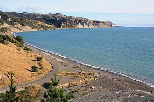
- Southern most point is Cape Palliser.
- Eastern-most point is East Cape.
- Western-most point is Cape Maria van Diemen.

Cape Palliser, the southern most point of the North Island.
Extremities of the South Island
- Northern-most point is Cape Farewell.
- Southern most point is Slope Point.
- Eastern-most point is West Head.
- Western-most point is West Cape.
Distance to Australia
Closest place to Australia is near Resolution Island lighthouse in Fiordland, a distance of 1,491 kilometres (926 miles).
The shortest distance from the New Zealand realm to to the Australian realm is New Zealand's Auckland Island to Macquarie Island in Australia - a distance of around 617 kilometres (383 miles).
Altitude extremities
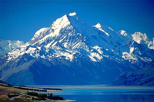
Highest point in New Zealand (and Australasia) is Aoraki / Mount Cook at 3754 metres (12316 feet) high.
There are 24 peaks in New Zealand over 3000 metres above sea level. They are all located in the South Island.
The highest mountain in the North Island is the volcanic peak of Mount Ruapehu. It is 2,797 metres (9,175 feet) high.
The lowest point in New Zealand is Taieri Plains at -2m below sea level.

Mount Cook is the highest peak in New Zealand and Australasia.
Time Zones
There are two two time zones in New Zealand.
- The main islands use New Zealand Standard Time (NZST).
It is 12 hours ahead of Coordinated Universal Time (UTC).
- The Chatham Islands to the east use Chatham Standard Time (CHAST).
It is 12 hours 45 minutes in advance of UTC.
Map instructions and tips
- In fullscreen mode, try dragging the orange person icon located at the bottom right onto a highlighted area to see a panorama image.
- To zoom in,double click on the map, use the scroll wheel on your mouse, or try the inbuilt slider.
- To move the map, click down or touch the map, then drag with your mouse or finger.
- Search and zoom in to a specific location using the search box at the top of the map.
- Right click on the map to instantly get latitude and longitude coordinates.
- Click a city linked to the left, for a Google Map & Street View.
- Try 'Satellite' mode for real aerial images.
- View more maps of New Zealand.
- View photos of New Zealand
Author & photographer: David Johnson (Virtual New Zealand). Providing a credit or link is appreciated.
Our content: logos, site names, text, photos, and website design are protected by international copyright law.
Original versions of our photos can be purchased / licensed & web versions can be shared subject to conditions.
