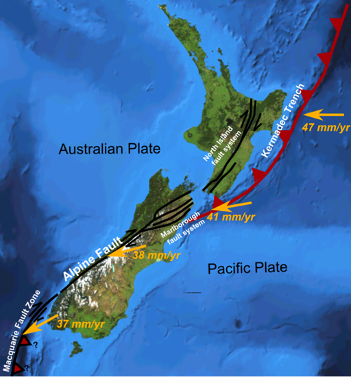
Earthquake Map of New Zealand

Earthquake faults in New Zealand. Click the map to see a volcanic map of New Zealand.
New Zealand is sometimes called the Shaky Isles. The country lies on the Ring of Fire which means it is a hotspot for earthquakes. There are aroung 20,000 earthquakes annually, most are small, but the country gets its share of big quakes too. High risk faults in New Zealand include the Alpine Fault, Wairararapa Fault, Wellington Fault, and Napier Fault.
The deadliest earthquake in New Zealand was the 1931 Hawke's Bay earthquake, (Napier earthquake) which claimed 256 lives followed by the June 2011 Christchurch earthquake which claimed 181 lives. The massive 7.8 Kaikoura earthquake in 2016 only claimed two lives due to being located mostly in a rural area and striking in the early hours of the morning.
Top 50 New Zealand earthquakes
Earthquakes ranked by magnitude on the Richter scale.
| Magnitude | Location | Year |
| 8.3 | Kermadec Islands | 21 Oct 1986 |
| 8.2 | Kermadec Islands | 15 Jan 1976 |
| 8.2 | Wairarapa | 23 Jan 1855 |
| 8.2 | Puysegur Trench | 24 May 1989 |
| 8.1 | Puysegur Trench | 24 Dec 2004 |
| 8.0 | Alpine Fault | 1717 |
| 8.0 | Alpine Fault | 1610-20 |
| 8.0 | Alpine Fault | 1100 |
| 8.0 | Wellington | 1450 |
| 7.8 | Kaikoura | 14 Nov 2016 |
| 7.8 | Fiordland | 15 Jul 2009 |
| 7.8 | Murchison | 17 Jun 1929 |
| 7.8 | Hawke's Bay | 3 Feb 1931 |
| 7.6 | Pahiatua | 05 Mar 1934 |
| 7.6 | Kermadec Islands | 07 Jul 2011 |
| 7.5 | Hawke's Bay | 23 Feb 1863 |
| 7.5 | Marlborough | 16 Oct 1848 |
| 7.5 | Cape Farewell | 19 Oct 1868 |
| 7.5 | Fiordland | 1826 |
| 7.4 | Kermadec Islands | 22 Oct 2011 |
| 7.3 | Hawke's Bay | 13 Feb 1931 |
| 7.2 | Fiordland | 22 Aug 2003 |
| 7.2 | Fiordland | 24 Jun 1942 |
| 7.2 | Wairarapa | 24 Jun 1942 |
| 7.1 | Darfield, Canterbury | 04 Sep 2010 |
| 7.1 | Inangahua Junction | 24 May 1968 |
| 7.1 | Arthur's Pass | 09 Mar 1929 |
| 7.1 | North Canterbury | 01 Sep 1888 |
| 7.0 | Kermadec Islands | 30 Sep 2008 |
| 7.0 | East Cape | 06 Feb 1995 |
| 7.0 | Wairarapa | 02 Aug 1942 |
| 7.0 | Wanganui | 08 Jul 1843 |
| 6.9 | Cheviot | 16 Nov 1901 |
| 6.9 | Nelson | 12 Feb 1893 |
| 6.8 | Gisborne | 20 Dec 2007 |
| 6.8 | Arthur's Pass | 15 Oct 2007 |
| 6.8 | Secretary Island | 10 Aug 1993 |
| 6.7 | George Sound | 18 Oct 2007 |
| 6.7 | Arthur's Pass | 18 Jun 1994 |
| 6.7 | Te Anau, Fiordland | 04 Jun 1988 |
| 6.5 | Taupo | 05 Jul 2011 |
| 6.5 | Edgecumbe | 07 Mar 1987 |
| 6.4 | Christchurch | 13 Jun 2011 |
| 6.4 | White Island | 29 Sep 2010 |
| 6.4 | Weber | 13 May 1990 |
| 6.4 | Motunau | 25 Dec 1922 |
| 6.3 | Christchurch | 13 Jun 2011 |
| 6.3 | Christchurch | 22 Feb 2011 |
| 6.2 | Lake Coleridge | 26 Jun 1946 |
| 6.2 | NE of New Zealand | 18 Nov 2011 |
| 6.0 | NE of New Zealand | 15 Sep 2011 |
Author & photographer: David Johnson (Virtual New Zealand). Providing a credit or link is appreciated.
Our content: logos, site names, text, photos, and website design are protected by international copyright law.
Original versions of our photos can be purchased / licensed & web versions can be shared subject to conditions.
